I had never heard of the "Carolina Bays" until last night. Scrolling through Facebook there was
a satellite image of the bays that was posted.

Interesting, huh? Just like me to start searching for info out of the subconscious
thought..... 'that's cool, let's hit google'. ( Opens the door to the rabbit hole)
After a few stops I found this article:
EXAMINATION OF SAGINAW BAY IMPACT STRUCTURE <<<
Make sure to visit the various header listings. This one is data from LiDAR
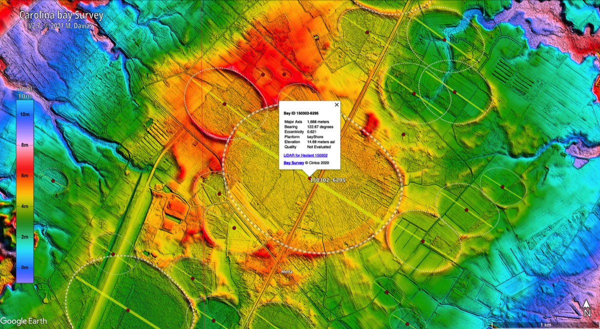
Sample image:
From what I gather there have been various "theories" on what caused these.
Then, I found this video:
This one is awe inspiring if you can fathom this type of event.
When you open the video there is a "Show More" toggle under the title and poster.
Click that for a large description and lots of links. I have copied and pasted it below the
fold to make it easier if you like. If some of the links don't work go to the video 'show more'

Have fun on your travels

IF you, as I do, like digging into these interesting findings, take a minute to imagine seeing this
type of event in real time.
There is so much we don't know, and stuff we don't know we don't know....
The Carolina Bays are a collection of thousands of elliptical depressions that cover the southeastern United States, from Mississippi to New Jersey.
With the help of LIDAR technology, we can now see these Carolina Bays in high resolution in Google Earth. As usual, there is a big controversy regarding the creation of the Carolina Bays. The mainstream opinion usually attributes their creation to a combination of wind and water erosion. Basically, lakes were formed a long time ago, and through the slow process of wind acting on the lake water, the elliptical shape was formed. Similar lakes are found up in Russia and Canada today, near the north pole. These are called "thermokarst lakes". (If you use Google Earth to view them, they are pretty fascinating!)
However, as you study the unique circumstances surrounding the Carolina Bays, the mainstream view does not hold up under scrutiny. Hence, a new theory was proposed, chiefly by Antonio Zamora. He argues that the Carolina Bays were caused by chunks of ice raining down from the atmosphere, after a comet impacted the Laurentide Ice Sheet over the Saginaw Bay area roughly 12,900 years ago.
If a comet were to hit the ice sheet at a low angle, then it could have launched millions of chunks of ice into the atmosphere. Upon re-entry, these ice chunks would have landed all throughout the Southeastern United States. Since they are relatively soft, being made of ice (not rock), they would then create the elliptical craters on the unconsolidated ground, but not on the rocky terrain.
Others have proposed a comet / asteroid exploding in mid-air. The resulting fragments would shower the region and create the elliptical bays.
If the Carolina Bays were created in a catastrophic event, this would help to explain the sudden extinction of the megafauna in North America during the Younger Dryas.
** Be sure to Right Click and "Open in New Tab" for all the links below!
If you'd like to explore the Carolina Bays in LIDAR, you'll need the standalone version of Google Earth: https://www.google.com/earth/download...
Here's the link for the KMZ file to be used in Google Earth: http://cbaysurvey.cintos.org/ *
* After you've downloaded the KMZ file, launch Google Earth. Go to File - Open... then choose the KMZ file. The Carolina Bays filter should now be active!
Antonio Zamora's YouTube
Channel: ![]() / antoniozamora-car...
/ antoniozamora-car...
Recommended Videos:
![]() • Carolina Bays Liq...
- Carolina Bays Liquefaction - Antonio Zamora
• Carolina Bays Liq...
- Carolina Bays Liquefaction - Antonio Zamora
![]() • Carolina Bays - T...
- Carolina Bays Timeframe - Antonio Zamora
• Carolina Bays - T...
- Carolina Bays Timeframe - Antonio Zamora
![]() • Ice impacts on Vi...
- Ice Impacts - Antonio Zamora
• Ice impacts on Vi...
- Ice Impacts - Antonio Zamora
![]() • Younger Dryas Imp...
- Younger Dryas Impact - Antonio Zamora
• Younger Dryas Imp...
- Younger Dryas Impact - Antonio Zamora
![]() • Carolina Bays Rev...
- Carolina Bays Review w/ Randall Carlson
• Carolina Bays Rev...
- Carolina Bays Review w/ Randall Carlson
![]() • "Ubiquitous Catas...
-Megafauna Extinction w/ Randall Carlson
• "Ubiquitous Catas...
-Megafauna Extinction w/ Randall Carlson
![]() • Flood Catastrophe...
-Overkill Hypothesis
• Flood Catastrophe...
-Overkill Hypothesis
![]() • Carolina Bays' Re...
-Carolina Bays Research Part 1
• Carolina Bays' Re...
-Carolina Bays Research Part 1
![]() • Carolina Bays' Re...
- Carolina Bays Research Part 2
• Carolina Bays' Re...
- Carolina Bays Research Part 2
![]() • Carolina Bays' Re...
-Carolina Bays Research Part 3 Recommended
• Carolina Bays' Re...
-Carolina Bays Research Part 3 Recommended
Articles:
http://cintos.org/CarolinaBays/index.... -Enigmatic Carolina Bays
https://science.howstuffworks.com/env... - Mainstream Opinion
https://books.google.com/books?id=uH7... - Secrets of the Carolina Bays
https://ui.adsabs.harvard.edu/abs/200... - Evidence for Extraterrestrial Impact
https://www.sciencedaily.com/releases.... - Climate Change -Megafauna Extinctions Linked
https://www.pnas.org/content/117/46/2... - Overkill and Glacial History
At first look of the pic, I thought those look like some kind of meteor impacts. The ice theory is interesting.
ReplyDeleteNemo
Petroleum shower. Dig 6+ feet down, and you get a thin lignitic (coal-like) soil layer in most of Eastern NC. Hence the Black River and other waterways.
ReplyDeleteIt's not just in eastern NC. While digging a couple holes to plant some trees years ago in my yard at the time, I came across the same 1" layer about 16" down. Probably not lignitic in this area. I thought it was perhaps the remnants of a past large forest fire. The soil above and below was a contrasting much lighter color and very sandy.
DeleteNemo
To get a real thrill and the most likely theory, check out Randall Carlson and Graham Hancock. There are also several eye opening podcasts from those gentlemen with Joe Rogan, very educational stuff, #'s 872, 961, and many more. Randall Carlson is a highly educated guy, and backs up his theories with documented facts. The scary part is that his information backs up a lot of Graham Hancocks theories. If Graham is right, we've been here a VERY long time and had several "reboots". We need to watch the sky and not for UFOs.
ReplyDeleteIt’s remnants from the last micro nova North America got hit the last time that is whu it jad to be discovered again…
ReplyDeletehttps://twitter.com/SunWeatherMan/status/1667270058928930830
ReplyDelete^^^ That is an even deeper hole to go down! https://www.youtube.com/@Suspicious0bservers/playlists
DeleteScientists have discovered lots of craters previously unknown using lidar and ground penetrating radar. Started back in the late 60s and early 70s when the US released satellite radar posts of the Nile Delta to quietly show the USSR that we could see underground, and then US sat radar analysts started pooping because they saw holes everywhere in Russia, until they figured out they weren't ICBMs or underground nuke test sites.
ReplyDeleteJust wait until the burning sulphur boulders deliver the wrath on the big banana Chiquitastan.
ReplyDeleteAll clowning aside, might be time for encore presentation of Nick Cage National Treasure movie.
You see there are some things left worth saving.
Spent many hours roaming around Carolina Bays, lots of Venus Flytraps, Sundews & Pitcher Plants.
ReplyDeleteLiquefaction Can be deadly
ReplyDeleteTL DR Liquefaction caused by earthquakes
ReplyDeleteRandall Carlson has deep-dived that subject and is an engaging presenter.
ReplyDeleteVery cool and disruptive topic!
Very nice!
ReplyDeleteSome years ago Robert Felix had some good material about Carolina Bays on his website, “Iceagenow”, in articles as well as in comments to them.
Unfortunately he passed away 2 years ago, and his website is no longer available.
Thanks for the indirect reminder of him. He was very personable and welcoming. I miss his internet presence.